
A total of 25 sites located across the Wicklow and Dublin Uplands participated in the SUAS Project with a combined total of 7,500ha. of upland habitats under management.
A total of 25 sites located across the Wicklow and Dublin Uplands participated in the SUAS Project. With a combined total of 7,500ha., each location has its own unique landscape characteristics, cultural heritage and management approach and undertook different actions under the guidance of the project.
Map of Participating Sites
The map below displays the location and topography of each of the participating sites.
Both Commonage and non commonage areas were inducted into the Project over three phases. The first Phase in 2018, the second in 2019 and a third phase in 2021. Each site is colour coded according to when they joined.
Phase 1 = Three Commonages and One Non Commonage, denoted in red
Phase 2 = Four Commonages and Two Non Commonages, denoted in blue
Phase 3 = Seven Commonages and Eight Non Commonages, denoted in yellow
Commonages Groups: Phase 1 & 2

Glasnamullen
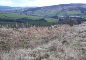
Located on the northeast of the Wicklow Uplands, on the slopes of Djouce Mountain and White Hill and facing the well-known Great Sugarloaf.

Granamore
Located in the west of County Wicklow, 5km south of the Blessington Lakes.
.
.

Ballybeg
Located on the slopes of Black Hill in the south part of County Wicklow.
.
.

Carrigeenduff
Located in the middle of the Wicklow Uplands, this very large commonage (674 ha) includes lands close to Lough Dan and the Glenmacnass Waterfall and the summits of Mullaghcleevaun East Top and Duff Hill.

Glassavullaun
Located in the Dublin Uplands, this large commonage (378ha) rises to the summits of Seefingan and Corrig Mountain. Streams rising within the commonage are important tributaries of the River Dodder

Corrasillagh
Located in the middle of the Wicklow Uplands, the commonage extends from the Glenmalure Valley rising to the shoulder of Lugnaquilla and includes the ridges and summit of Cloghernagh.
Slievemweel
Located close to Askanagap in the southern Wicklow Uplands. Streams rising within the commonage are tributaries of the Derry Water River
Non-Commonage Upland Areas: Phase 1 & 2

Powerscourt Paddock
Located in the northeast of County Wicklow, to the south of the famous Powerscourt Estate, and rising to the summit of Djouce Mountain.

Kilmashogue
Located on the slopes of south County Dublin’s Two Rock Mountain (also known as the Fairy Castle).
.
Ballynultagh
Located in the Wicklow Uplands, Ballynultagh adjoins the commonage of Carrigeenduff and extends to summits such as Mullaghcleevaun East Top.
All Sites: Phase 3

Ballinastoe

Ballybraid.
Ballynultagh
Coolbawn
Cunard
Drummin
Garryhoe
Glassamucky Brakes
Glencap
Laragh East (1)
Laragh East (2)
Laragh West
Luggala
Mangans
Slieveroe

Main Street,
Roundwood,
Co. Wicklow.
declan.suas@wicklowuplands.ie
www.wicklowuplands.ie/SUASproject

Project Manager,
SUAS Pilot Project.
The SUAS Pilot Project is operated by a wholly-owned subsidiary of Wicklow Uplands Council. Company Name: WUC-SUAS. CRO623917