Article first published in:
Wicklow Mountain Views – The Newsletter of the Wicklow Uplands Council.
Issue No. 28.
New Maps for Co. Wicklow
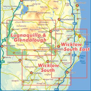
EastWest Mapping has recently published three new detailed 1:25,000 scale maps for County Wicklow.
Combined, they largely cover the area south of the Wicklow Gap including Lugnaquilla & Glendalough, extending southwards to Tinahely and Shillelagh and across to the Irish Sea coastline between Arklow and Wicklow town.
The maps present the landscape in great detail, with every building outside of urban areas along with all ditches, main fences and trails being featured.
Members of local communities have contributed advice and knowledge of heritage sites and placenames found in their localities. The maps also show the locations of many rural businesses and highlight the principal recreational facilities and activities found in the region.
We hope to extend this detailed coverage for county Wicklow in 2019, with a focus on the areas north towards the M50.
Priced at €12.50 in standard paper or €19.50 for fully waterproof maps, these are available from www.eastwestmapping.ie or selected local bookshops and retail outlets.
Barry Dalby, EastWest Mapping

Supported By


